Kaurna History
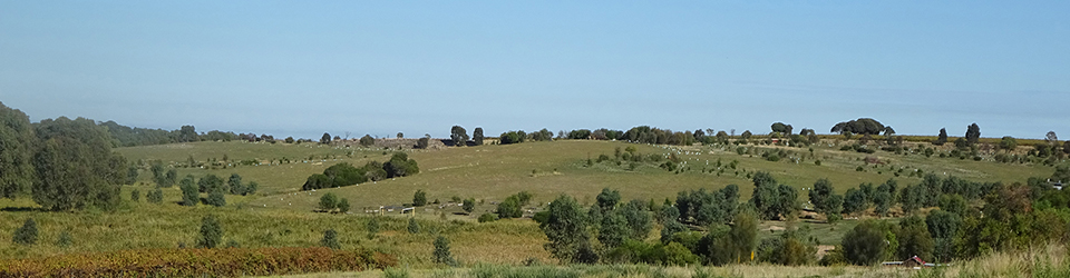
The Willunga Basin, named after the Kaurna place name Willangga, is a prime traditional Kaurna cultural landscape, rich with the history of the Kaurna Meyunna Kaurna People. There are numerous Kaurna camping places, burial grounds and Dreaming sites known in the region.
The modern story begins about 7,000 years ago at the end of the last Ice Age when the flooding of the plain to the west by the rising seas came to an end. Wonggayerlo Western sea (Gulf St. Vincent) had been created and the coastlines of the Fleurieu and Yorke Peninsulas soon formed. The stabilisation of the sea level led to more stable patterns of settlement and the emergence of broad cultural areas as the people adapted to the new physical landscape.
L50K is part of an ancient Kaurna camping place, occupied for up to 7,000 years, for as long as Wonggayerlo has existed. Detailed archaeological research nearby in coastal sandhills at Moana and another campsite give an occupation period of 6,500-7000 years. An archaeological survey of Lot 50 revealed campsite artefacts over most of the property.
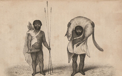
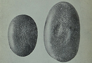 Hammer Stones, Moana Sandhills, Tindale 1926
The Kaurna name for this place, announced by Karl Telfer, Senior custodian, is Kanyanyapilla. This is not a new name, rather it is the name recorded for the locality in 1839 during the survey of District C. The name was recorded by Louis Piesse, Surveyor’s Assistant and also Clamor Schurmann, missionary and linguist, whilst on a journey to Encounter Bay in July 1839 with Kaurna man Wauwitpinna (also recorded as Wattewattipinna) and Matthew Moorhouse, Protector of Aborigines. They camped at Kanyanyapilla (on a spot the other side of the now Victor Harbor Road) on 24 July 1839.
Variant spellings have been recorded: Kanjanjapilla, Canyanyapella, Cunyunyapella, Cunyanyapella, Canyauapella, Cananapella and Cananyapella and variations of the name were used by the first settlers for the locality or their properties.
Kanyanyapilla has different possible meanings depending on how it is deciphered linguistically; place of many camp ovens, two crowds or heaps, two lots of rocks and a multitude of eagles. L50K was a well-used camping place with many camp ovens there and Wedge tail eagles were common in the Willunga Basin. Three were in the sky above Kanyanyapilla in November 2015. (The ongoing research of Chester Schultz on Kaurna place names is acknowledged and his assistance most helpful.)
Kanyanyapilla is just a few kilometres to the west of the Kaurna travelling route which ran from Ngurlongga Noarlunga south towards Willangga Willunga and further to Encounter Bay and the south coast. An 1840 map by surveyor John McLaren shows the Kaurna track through the Willunga Basin
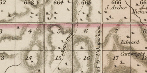 McLaren: Extract from Country south of Adelaide from O’Halloran Hill to Mt. Terrible including District C showing Native Track in Sections 46, 53, 61, 71, 72, 82
Paid Kaurna guides worked with the surveyors and information on Kaurna place names and travelling routes was therefore recorded. This helps explain the prevalence of Kaurna place names in the Willunga Basin and on the Fleurieu Peninsula whilst few Kaurna names are utilised north of Adelaide.
1839 THE NATIVES
It is a subject of the utmost gratification to observe the progress made in bringing the natives to a state of civilization. … Several of them are also employed in the Survey Department at Yankalilla and Aldingha (Aldinga), who receive rations and pay the same as white laborers. … This is truly gratifying, and promises well for the success of our schemes for civilizing our state. (South Australian Register 10.08.1839)
In addition the colony’s second governor, George Gawler, favoured indigenous place names:
In regard to the minor features of the country to which the natives may have given names, the governor would take the present opportunity of requesting the assistance of the colonists in discovering and carefully and precisely retaining these in all possible cases as most consistent with property and beauty of appellation.
Furthermore, all information on this subject should be communicated in precise terms to the Surveyor–General who will cause memoranda to be made of it and native names, when clearly proven to be correct, to be inserted in the public maps.
(Government Gazette, 1839)
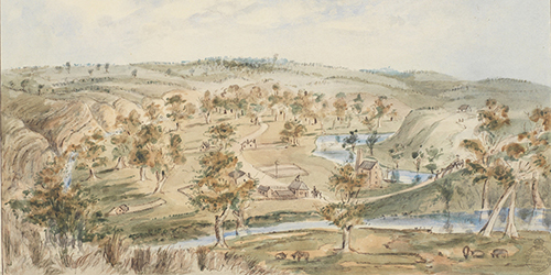
L50K is just part of an ancient Kaurna camp site. The swamp area would have been rich in both mai vegetable foods and paru game, along with permanent water. The length of occupation of the camp site is likely to be up to 7,000 years. Archaeological research nearby in coastal sandhills at Moana and another campsite give an occupation period of 6,500-7000 years. An archaeological survey of Lot 50 revealed campsite artefacts over most of the property.
Kanyanyapilla is only several kilometres inland from the coastal summer camp places, coastal traveling corridor and the Tjirbruki Munaintya (Dreaming) sites of Karkungga Red ochre place (at Ochre Cove, Moana), Wirruwarrungga (at Port Willunga) and Witawali (at the southern end of Wangkondilla [the Washpool] at Sellicks Beach). Karkungga supplied various ochres for ceremony and trade, Wirruwarrungga was a fresh water spring site on the beach with another camp place behind the sandhills at the mouth of the Willunga Creek. Witawali was a fresh water spring site just south of Wangkondilla, a major workshop site used for the curing and drying of animal skins, from which items such as cloaks and bags were made.
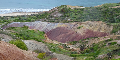 Karkungga ‘Red ochre place’
Several Kaurna people are known of who had an association with the region before and after colonisation. Mullawirraburka (c1811-1845), also known by the colonisers as King John or Onkaparinga Jack, had responsibility for Country in the region and part of his parngkarra clan territory was inland from Ngaltingga (Aldinga). In contemporary terms he would be regarded as senior custodian of the Willunga area (Gara, 1998:93). It is probable that Mullawirraburka used Kanyanyapilla before and after colonisation. Dr. W. H. Leigh, ship’s surgeon, aboard the South Australian Company ship South Australian had contact with Mullawirraburka and recorded in his journal some events he shared with him, one a kangaroo hunt. Leigh provided a drawing of Mullawirraburka.
 Two men, one Mullawirraburka, returning from a kangaroo hunt, c1837
It is probable that two other prominent Kaurna men, Ityamaiitpinna (c1814-c1860), known by the colonisers as King Rodney and Kadlitpinna (born c1804), known by the colonisers as Captain Jack, had knowledge of, or visited, Kanyanyapilla. Colonial artist Martha Berkeley painted them with Mullawirraburka.
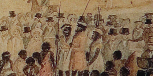 From left: Mullawirraburka, Kadlitpinna and Ityamaiitpinna, 20 October 1838: From ‘The first dinner given to the Aborigines, 1838’ (Berkeley, AGSA)
Within twenty five years of colonisation Kaurna had been completely dispossessed of their lands and traditional movements, gathering and hunting practices were no longer possible.
“I fear for their future.” George Manning, McLaren Vale colonial settler.
“There is indeed, a certain sadness associated with our pioneering work.” Richard Hill, Willunga colonial settler.
Surviving Kaurna were relocated to mission living or became fringe dwellers. A Depot (Rations) Station was established at Willunga, c1858, at what is now the Police Station and Courthouse. Several Kaurna people are known to have been located there into the 1860s including Sam and Maria and their two children, Old Willimy (probably Tairmunda) and Old Charlotte and her son, Phillip. Charlotte was possibly the wife of Ityamaiitpinna. The Willunga Depot was in operation for only several years and provided for not only Kaurna survivors but also Ramindjeri who often came up there to ‘sit down’ or when in transit to Adelaide, as did the Ngarrindjeri. At its peak there were ‘70 to 90 natives, men, women & children, two of the men are blind and several old & infirm, not able to move much about from the worley.’ This number suggests a seasonal movement as the normal numbers were much closer to twenty and under. In October 1859 the keeper reported that ‘There has been seven deaths and no births that I am aware of during the last four months’ reflecting the declining Aboriginal population.
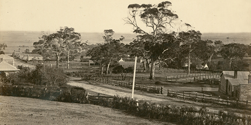
Police Station and Courthouse, Willunga c1872 (SLSA)
During the colonisation process land was reserved for Aboriginal occupation (as farmers/settled labourers). This was not successful and the land was then initially leased to settlers and then later resumed for other purposes in the late 19th century. Five Sections of 80 acres were set aside in the Hundreds of Noarlunga and Yankalilla but none in the Hundred of Willunga.
There are several reports of Kaurna and Ramindjeri men (and possibly Ngarrindjeri) undertaking agricultural work in the district between the 1840s and 1860s.
1842 WILLUNGA DISTRICT
HARVEST – The corn is ripening fast and all hands are engaged in cutting and carrying. A large party of natives came up from Encounter Bay on Friday evening to Oxenbury Farm, in this district, and offered their services to cut corn. The following morning, Mr Hewett employed six of them to reap and bind, and we must confess, we found two of them good reapers – one, especially, would surpass some whites that profess to be able hands. There can be no doubt that, with a little instruction, these natives could be made very serviceable in gathering, in the harvest. (Southern Australian 16.12.1842)
1860, January
Several of them left for McLaren Vale about three weeks ago and the remainder have gone to that place in order (as they say) to find employment but I believe they have gone on their “annual round”. (Report to the Commissioner of Crown Lands & Immigration on Aboriginal ration depots)
During harvest time I occasionally employ a native to assist my sons and me with reaping. Their labour is rewarded with either clothing, blankets or tobacco. It is sad to relate that a few miserly farmers cheat them, for I learned that on one occasion, three native women worked for six weeks, and were paid only sixpence per day (George Manning, Reflections 1870)
One hundred years later Aboriginal people, mainly Ngarrindjeri from Point McLeay Mission (now Raukkan), worked in the McLaren Vale district in the agricultural and viticultural industries from the 1940s to the 1960s.
European History
The first Europeans to sight the region were Englishman Captain Matthew Flinders, aged just 28, and the seventy people on board the Investigator when they sailed past what is now the Willunga Basin on 27-28 March, 1802. Just sixteen days later on the morning of 23 Germinal, Year 10 of the Republic (13 April, 1802), the Frenchman Captain Nicolas Baudin sailed passed the site of Port Willunga on the Le Geographe. On board were over 100 people, adding to the number of Europeans to see Kaurna Yerta. Twenty nine years later on 15 April, 1831, Captain Collette Baker and four companions on the Isabella went ashore near the mouth of the Onkaparinga River and spent a week examining the coastal plains. They followed the Onkaparinga as far upstream as the horseshoe bend at Noarlunga and also made their way to the Mount Lofty Ranges ascending Mount Lofty (named by Flinders in 1802) on 19 April, 1831. Captain John Jones, a whaler based in Launceston and skipper of the 34 ton schooner, Henry, made several journeys in the early 1830s to Kangaroo Island and the region, including sailing up the eastern side of the gulf in 1833.
There were other European visitors in the early 19th Century, sealers and whalers based on Kangaroo Island, who raided the coastal area to kidnap women. Sealers, and whalers in general where known for their cruelty against Aboriginal people from Western Australia through to Tasmania.
The first official European expedition to travel through the Willunga Basin post colonisation was in June 1837, six months after the proclamation of the colony. It was led by Colonel William Light, Surveyor-General, and James Hurtle Fisher, Resident Commissioner. They set off from Glenelg on 16 June for Encounter Bay accompanied by Messrs Stephen Hack, John Morphett and a party of thirteen Marines from the Buffalo. The first night they camped in a ‘beautiful valley’ (Hurtle Vale, near Morphett Vale) and because of wet weather and difficulties with bullocks and carts remained there until the 19th when the Marines were sent back to Adelaide and a smaller party proceeded south. On the 19th and 20th they camped at the Onkaparinga River before journeying on to Encounter Bay, crossing the ranges near Willunga. Unfortunately there was no account of their full journey published but of the river Light wrote:
The river is … nearly three miles from the sea a beautiful one, full hundred yards wide, and very often more, with deep water, and we found the water at ebb tide fresh to within a mile of the sea, and the country is not only beautifully picturesque, but rich in soil. I have seldom seen a place more inviting than this, and I have no doubt some future time will form a country town here of considerable consequence.
The 1838 painting Onkaparinga visualised what Light described and the 1850 painting Noarlunga confirmed Light’s prediction.
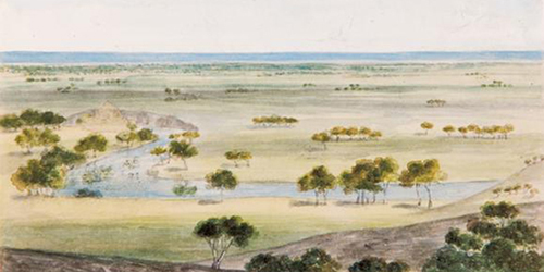 Onkaparinga, South Australia 1838, Skipper, J. M. (AGSA)
 Noarlunga 1850, Cawthorne, W. A. (SLNSW)
In 1839 surveyors, led by John McLaren after whom McLaren Vale is named, were at work in the southern districts mapping the land into Sections to provide land for the holders of Preliminary Land Orders (a land order mostly purchased in England as part of the establishment of the province) and other settlers.
Of particular note is that the survey parties included paid Kaurna guides. Information on Kaurna place names and travelling routes was therefore recorded which helps explain the prevalence of Kaurna place names in the Willunga Basin and on the Fleurieu Peninsula (in contrast to the few Kaurna names used north of Adelaide).
A survey depot was established on the Government Reserve at Willunga in 1839 and a sketch by Surveyor-General Edward Frome c.1840 depicts three early buildings: the Police Station (left), Survey Store (centre) and Post Office (right). All buildings were temporary, constructed of wattle and daub. There is another early sketch, c.1844, by noted colonial artist George French Angas of Atkinson’s farmhouse at Willunga.
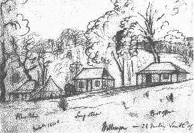 Willunga – 28 miles south of… (Adelaide) E. C. Frome, c.1840
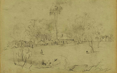 At Willunga, Atkinsons G. F. Angas c.1844 (NLA)
By mid-1839 land in the Willunga Basin was available for selection and settlement commenced soon after. In June 1839 Scotsman James McLeod acquired several Sections in District C (Willunga Basin region). He was one of the first, if not first, to select land in District C in the McLaren plains (McLaren Vale) region. His selection was most likely assisted by his friend James Hawker, a member of the District C survey team.
By November 1839 at the latest, he and wife Mary were living on their property Tarranga (or Taranga) to the north of the present township of McLaren Vale. They were visited by Governor Gawler’s party en-route to Willunga and the lower Murray on November 22nd 1839.
The McLeods were soon followed by others, on 2nd January 1840 noted early settlers ‘Charles Hewitt and William Colton with their families – settled in the McLaren Vale region at a place they called the Doringa Valley. Within months, they and like-minded settlers were clearing scrub and timber and creating farms modelled on their English experience’ (City of Onkaparinga).
They were soon followed by others, on 2nd January 1840 noted early settlers ‘Charles Hewitt and William Colton with their families – settled in the McLaren Vale region at a place they called the Doringa Valley. Within months, they and like-minded settlers were clearing scrub and timber and creating farms modelled on their English experience’ (City of Onkaparinga).
By the end of February 1840 a twice weekly freight and passenger coach service between Adelaide and ‘the rapidly improving township of Willunga’ had been commenced by William Deacon travelling via ‘The Horseshoe Ford, Onkaparinga, McLaren’s Valley, Tarranga, Mr. Hewitt’s Farm, The Bay of Biscay, and thence to the Police Station at Willunga’ (Southern Australian 27.02.1840 p. 2).
In August 1840 a newspaper report outlined that:
A few miles beyond the Onkaparinga is the beautiful valley called McLaren Vale. In it there are at present twelve settlers, who possess stock to the amount of 2000 sheep, and 200 hundred head of cattle. The district only being newly settled, agriculture has not yet made much progress. About 70 acres are however, under crop, and the grain – such as was early sown especially – is looking remarkable well. The Willunga district, a few miles further to the southward, is also beginning to be settled. (Adelaide Chronicle, 26 August, 1840)
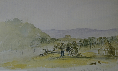 McLaren’s Vale, Apr 24, 1840, E. C. Frome (AGSA)
Lot 50 History
Under the colonising land tenure system the land of Lot 50 was granted to William Edleston on the 7th day of November 1839 under the Hand and Seal of George Gawler, Esquire, Resident Commissioner and Governor of the province of South Australia. It was part of Section 194, District C (now Hundred of Willunga). By coincidence Governor Gawler and party, including his daughter, passed about a mile away two weeks later on his way to Willunga on 22nd November, on route to Lake Alexandrina to then journey up the River Murray.
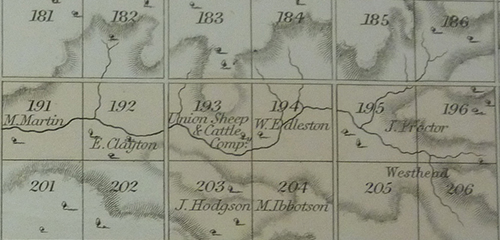 Extract from McLaren, J. (1840) Country south of Adelaide from O’Halloran Hill to Mt. Terrible including District C and portions of Districts B and D.
Edleston of Sowerby Bridge near Halifax, county York (Yorkshire), England, purchased South Australian Land Order No. 796 on 9th November 1838 for £80 or £1 per acre. He was the first absentee owner. In June 1841 he agreed to sell the land to Harry (Henry) Hughlings, Sharebroker, of Halifax for £100 and on the 5th December 1844 the transfer of ownership occurred with an Edward Wright, the younger, of Adelaide also taking a share.
Hughlings was a speculator and Colonial Land Agent. He held several Land Orders and Adelaide Town Acres as well as several parcels of land in New Zealand which he visited in 1843 arriving on the Industry. He also held shares in the South Australian Mining Association. He on-sold Section 194 on 20th January 1855 to John Sutcliffe of Blackwall, Halifax for £600, taking a profit of £500, or 500%, for the 11 years he held the land. It is not known fully what role Edward Wright played in Adelaide. In the 1850s he was a land agent who also represented absentee proprietors. It appears that Edward Wright, the senior, was a surgeon who was dismissed from his position in London in 1830 ‘for frequent drunkenness, neglect of duties and undue familiarities’ and was then amongst the first arrivals in South Australia aboard the Cygnet in September 1836.
John Sutcliffe, a bachelor, later of Ovenden Hall near Halifax, died in February 1867. Gamaliel Sutcliffe, his nephew of Stoneshay Gate, Heptonstall, was his heir and ‘entitled to the land in South Australia, the rents of which are received by Lavington Glyde, Esq.’. Glyde was an accountant and later parliamentarian who had arrived in South Australia from Yorkshire in July 1850 aboard the Agincourt.
 Ovenden Hall, Halifax, Yorkshire, August 1913
Gamaliel Sutcliffe applied to bring the land under the provisions of the Real Property Act 1861 on the 1st April 1871 as part of the sale of the land for £650 to Amelia Pomery, widow, of Willunga. On the 20th October 1871 the land was formally transferred to Pomery and the first certificate of title, Volume 159, Folio 107 was issued. Thus for the first 32 years Section 194 was held by absentee English landlords from Yorkshire.
Pomery was from Cornwall and arrived in South Australia in September 1839 with husband Richard aboard the Prince Regent. They first lived at Brown Hill Creek in a tent on the site of what is now Scotch College, Torrens Park. They settled in the Willunga district in 1845 on Section 186, known as Vineyard Farm (on Branson Road) and owned by George Fife Angas. They leased several sections of land. Section 194 was leased from 1853 and in May 1854 they purchased Section 196. Richard died in April 1859 leaving Amelia with eight children, the youngest just 11 months. She continued farming and managing the land as attested by a Public Notice in October 1859. (Section 196 is one section further to the east of Section 194)
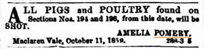 Public Notice (Adelaide Observer 29.10.1859)
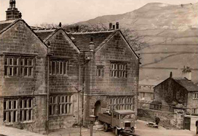
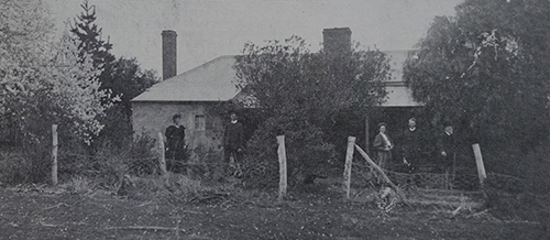
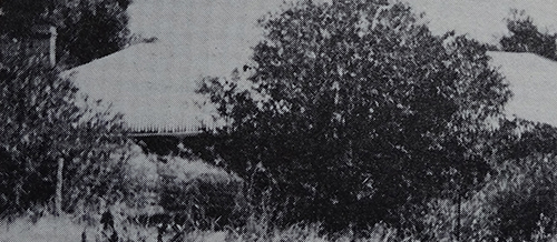
In 1871 she mortgaged other land to complete the purchase of the family homestead on Section 194. It has not been established when they built/occupied the homestead which she named Salem, meaning House of Peace. Although still standing in 1977 only a chimney now remains of the homestead which was located on the southern half of Section 194 (not on Lot 50). In April 1872 she leased Section 194, along with most other land holdings, to William James Blacker, her son-in-law who had married daughter Elizabeth in October 1871 at Salem Farm. In April 1878 Amelia remarried and in 1879 sold all her land to James Blacker, William’s father. Section 194 was soon passed to William who was later to become a Member of Parliament. The Blacker family leased of owned the land for eighty-five years (1872-1957).
 Blacker family at Salem c1914 (Pomery & Merrett, 1981)
 Salem 1977 (Pomery & Merrett, 1981)
From 1957 to 2015 the Bosworths, Irwins and Chaffeys held the land. Comprising 80 acres (32.4 ha) the Section has now been subdivided into three titles. In the 176 years since 1839, Malone is the ninth family name attached to the land title now known as Lot 50.
Cropping and Grazing
It is understood that Lot 50 was variously used for cereal cropping and cattle grazing up until about 1990. Cattle particularly graze young reeds. In the 1960s and 70s it was used to keep thoroughbred horses and over the last several years it has been used for horse agistment.
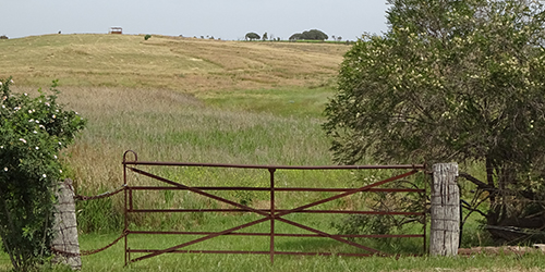 Farm gate with Redgum posts
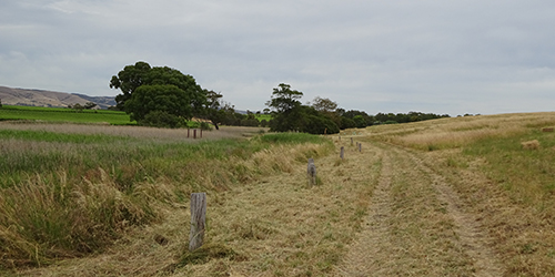 Old swamp edge fence line revealed, Nov. 2015
Sand Mining Proposal
Sand mining to produce building and construction sands has been a major extractive industry in the Willunga Basin, operating since the early 20th century. One large mine is still operating at Maslin Beach. Others have now been exhausted and closed; one now used as a waste dump, another abandoned and derelict, and another revegetated. The mining operations reveal multi coloured sands and also provide the ferruginised sandstone, the coloured stones.
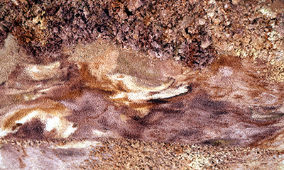 Maslin Coloured Sands
In the early 1990s it was proposed that Lot 50 be sand mined. Minor sand mining had been undertaken immediately to the west in the 1970s. Geological investigations were undertaken and 700,000 tonnes of recoverable sand identified comprising sands suitable for glass making and foundry use, beach replenishment, garden sand, general trenching sand and 350,000 tonnes of material for use as basic fill. The deposit includes red, yellow, orange and brown coloured sands but nothing as complex and colourful as the Maslin sands. Although the deposits are only a few kilometres apart, they are geologically quite different.
The necessary approvals for mining were sought but in July 1993 the then Minister for Aboriginal Affairs refused approval. The proposal was revisited on and off until 2006 when in December that year the then Minister for Aboriginal Affairs again refused approval although there was an agreement with the Kaurna Heritage Board for the mining to proceed. The mining proposal was then abandoned.
About a million years ago in the mid Pleistocene Age Lot 50 had been beach side, a dunal system surrounding an ocean bay.
Thanks to Olliver Geological Services for geological information.
